New York Winter Storm 2025: Heavy Snow and Arctic Blast Disrupt Northeast Travel
For New Yorkers, the first “real” snow of the season usually brings a mix of childhood wonder and adult anxiety. On the weekend of December 13–15, 2025, that anxiety took center stage as a fast-moving but potent North American winter storm swept across the Northeast, burying parts of the state under record-breaking snow and plunging the region into a dangerous Arctic deep freeze.
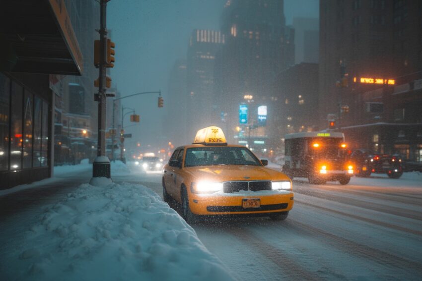
What started as a quiet December Saturday ended with sirens, salt trucks, and a skyline blurred by white-out conditions. By Sunday night, the storm had left its mark: record snowfall at major airports, thousands without power, and a reminder that when the Arctic air pushes south, the “City That Never Sleeps” has no choice but to slow down.
Record Snowfall: From Central Park to Perrysburg
This wasn’t just a dusting. The storm delivered the heaviest accumulations the region has seen since 2022. While New York City saw a manageable but impactful 2.7 inches in Central Park—marking the earliest in-season inch of snow since 2019—other parts of the state were buried.
Perrysburg, New York, took the crown for the highest accumulation, recording a massive 23.7 inches of snow. Meanwhile, Long Island felt the brunt of the coastal bands. Islip reported a daily record of 5.8 inches, its snowiest day in nearly four years. These weren’t just numbers on a map; they were impassable driveways and buried cars that kept residents trapped well into Monday morning.
Chaos in the Skies and on the Tracks
For travelers, the timing couldn’t have been worse. As the holiday season kicked into high gear, the storm forced ground stops at John F. Kennedy International (JFK) and Philadelphia International Airports.
- Flight Disruptions: Over 1,000 flights were delayed nationwide, with over 100 outright cancellations.JFK alone set a daily snowfall record of 4.6 inches, turning the tarmac into a slow-moving puzzle of de-icing trucks.
- Commuter Struggles: Within the five boroughs, the MTA felt the strain. The 1, A, and R subway lines experienced significant delays as crews battled freezing switches and icy outdoor tracks.
- Highway Hazards: The Southern State Parkway on Long Island became a scene of tragedy, where slick conditions led to a fatal crash involving a 20-year-old driver. In total, the storm was linked to at least four fatalities across the country, a sobering reminder of the danger lurking beneath the “pretty” snow.
The “Deep Freeze” Follow-Up
If the snow was the first punch, the temperatures were the knockout. Following the precipitation, a blast of Arctic air swept down from Canada. Meteorologists warned of wind chills plummeting to -18°C (0°F) in the city and even lower in the Poconos and upstate regions.
Governor Phil Murphy of New Jersey and New York officials issued stern warnings: Avoid unnecessary travel.In Mercer County, NJ, over 2,000 residents lost power as heavy, wet snow snapped tree limbs like toothpicks.
A Community Under White-Out
Despite the chaos, the human spirit remained resilient. In Brooklyn, the Manhattan Bridge became a backdrop for families who refused to let the cold dampen their spirits. Sleds emerged from storage, and for a few hours, the Brooklyn-Queens Expressway was lined not just with salt spreaders, but with the sound of children laughing in the freshly fallen powder.
However, the reality for many was a weekend of shoveling and shivering. New York City’s Department of Sanitation deployed a literal army of plows and salt spreaders, working 24/7 to ensure that by Monday morning, the city could—at least partially—get back to business.
Looking Ahead: Is This the New Normal?
This early-season “Arctic intrusion” aligns with broader 2025–2026 winter forecasts influenced by a shifting La Niña pattern. While some years remain dry, 2025 is proving to be part of a trend toward wetter, snowier winters for the Northeast.
As the storm clears, the focus shifts to a new threat: Holiday Travel Friday. Forecasters are already eyeing a new cross-country system that could bring 60 mph gusts and heavy rain to the same regions currently digging out from the snow.
Safety Checklist for the Next Round
If you’re living in the path of these late-December systems, preparation is your best defense:
Keep the Tank Full: Never let your car’s fuel drop below half a tank to prevent fuel line freeze-ups.
Backup Power: Ensure your devices are charged, and you have a supply of batteries.
Check on Neighbors: The elderly and vulnerable are most at risk during the sub-zero wind chills that follow these storms.