Reading view

The Hidden Corridors of Mai Po: Redefining Hong Kong Ecotourism Through Enhanced Access and Conservation

The Hidden Corridors of Mai Po: Redefining Hong Kong Ecotourism Through Enhanced Access and Conservation

The landscape of sustainable travel in Hong Kong is set to change dramatically as plans to revitalise access to the Mai Po Nature Reserve are put into action. Fanny Yeung, Executive Director of the Travel Industry Council, stated that the partial opening of the Mai Po closed area is expected to be a powerful catalyst for the local tourism sector. However, there has been a strong emphasis on the need for authorities to maintain strict conservation safeguards and a meticulous approach to accessibility management.

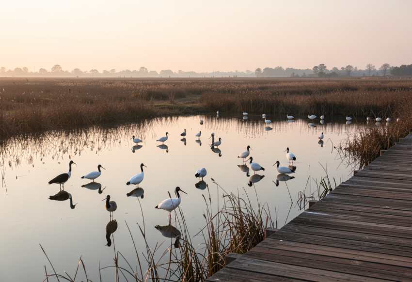
Mai Po, a Ramsar Convention-listed site, is internationally recognised for its exceptional biodiversity and role as a critical sanctuary for migratory bird populations. By increasing access to this ecological jewel, a more diverse demographic of international and local tourists is expected to visit the region, cementing Hong Kong’s reputation as more than just a concrete jungle.

Simplifying the Gateway to Nature

Legislative shifts are currently being navigated to ensure that the wonders of the wetlands are more reachable for the general public. In a document submitted to the Legislative Council by the Security Bureau earlier this February, a proposal to amend the Frontier Closed Area Order was detailed. This amendment is intended to facilitate more convenient entry into Mai Po by removing traditional bureaucratic hurdles.

Under the proposed framework, the requirement for a Frontier Closed Area Permit, which is currently issued by the police, would be abolished for those visiting the designated zones. Instead, a streamlined process would be implemented where citizens are only required to obtain a Mai Po Marsh Entry Permit. This permit is managed by the Agriculture, Fisheries and Conservation Department (AFCD) in strict accordance with the Wild Animals Protection Ordinance. Such a change is viewed as a vital step in transitioning from a security-focused restriction to a conservation-led management style.

Strengthening the Image of Environmental Education

The potential for growth in specialized travel sectors is immense. It is anticipated that the opening of these restricted zones will attract a surge of ecotourism enthusiasts, dedicated bird watchers, and academic groups. Furthermore, the development of sophisticated study tours is being encouraged, as these initiatives are believed to strengthen Hong Kong’s standing as a premier hub for environmental education within the Asia-Pacific region.

By allowing visitors to witness the delicate balance of the Pearl River Delta’s ecosystem firsthand, the city can foster a deeper global understanding of wetland preservation. The educational value of Mai Po extends beyond simple sightseeing; it offers a living laboratory for students and researchers to study intertidal mudflats, mangroves, and the complex migratory patterns of rare species like the Black-faced Spoonbill.

Strategic Management and Seasonal Sensitivity

Despite the excitement surrounding increased accessibility, the importance of “quality over quantity” remains a central theme in the government’s strategy. Suggestions have been made that the total number of visitors and the duration of their stay within the restricted areas must be subject to strict controls. To ensure that the human footprint remains minimal, the arrangement of professional guides to lead visitor groups has been proposed as a mandatory or highly encouraged measure.

Ecological sensitivity is particularly heightened during specific times of the year. It has been noted that visit planning must take into careful account the nesting periods and peak migratory seasons of the avian residents. Human activity should be harmonized with the natural rhythms of the wildlife to prevent habitat fragmentation or distress to the birds. This seasonal approach to tourism ensures that the reserve remains a viable sanctuary for generations to come.

Logistical Considerations for a Fragile Environment

The physical infrastructure and transport logistics surrounding the reserve are also under review. Due to the narrow pathways and the sensitive nature of the marshes, a recommendation has been made to implement a limited quota on the number of small-to-medium-sized coaches allowed to enter the vicinity. This measure is designed to mitigate noise pollution and physical congestion, ensuring that the tranquillity of the site is preserved for both the animals and the visitors.

The Security Bureau and the AFCD are expected to work in tandem with organizations like WWF-Hong Kong, which has managed the reserve since the 1980s, to refine these operational details. The goal is to create a seamless experience that balances the public’s right to appreciate natural heritage with the undeniable duty to protect it.

Looking Towards a Sustainable Future

As Hong Kong expands its tourism offerings under the “Tourism Blueprint 2.0”, the integration of ecology and travel is a forward-thinking step. The proposed changes to the Frontier Closed Area are more than just about removing fences; they are also about raising awareness of the intrinsic value of conservation.

By making Mai Po a more accessible but strictly regulated destination, Hong Kong demonstrates that economic revitalisation and environmental stewardship are not mutually exclusive. As the legislative process progresses, both the travel industry and conservationists remain vigilant, ensuring that the primary focus remains on the “wise use” of these global wetlands.

The post The Hidden Corridors of Mai Po: Redefining Hong Kong Ecotourism Through Enhanced Access and Conservation appeared first on Travel And Tour World.

Catbalogan City, Philippines: How Scientific Cave Mapping is Revolutionizing Sustainable Ecotourism in Samar

Catbalogan City, Philippines: How Scientific Cave Mapping is Revolutionizing Sustainable Ecotourism in Samar

The hidden depths of Catbalogan City, Samar province’s vibrant capital, are currently being revealed through a meticulous combination of science and sustainability. Long regarded as a gateway to the rugged beauty of Eastern Visayas, the city is now establishing itself as a pioneer in subterranean resource management. A comprehensive cave surveying and mapping training session was recently held from February 16 to 19, 2026, marking a significant step forward in the region’s quest to become a premier ecotourism destination. The Catbalogan City Tourism, Culture, Arts, and Information Office spearheaded this initiative to ensure that the city’s natural wonders are not only promoted but also preserved for future generations.

The groundwork for this training was laid during a reconnaissance mission in July 2025, which confirmed 24 distinct caves in the barangays of San Andres, Totoring, Lobo, and Cagutian. These sites, which were previously known only to locals and occasional adventurers, are now being integrated into a formal framework of environmental stewardship. The shift to a science-based approach reflects a growing recognition that tourism must be balanced with the protection of fragile ecosystems. By transforming local volunteers and government employees into skilled mappers, the city fosters a sense of ownership and responsibility for these irreplaceable natural resources.

Empowering Communities through Technical Mastery

The four-day training programme was designed to bridge the gap between raw exploration and professional speleological standards. Participants were immersed in a rigorous curriculum that spanned theoretical foundations, hands-on fieldwork, and modern digital data processing. Much of the practical application was focused on the karst landscapes of Barangay Cagutian, where digital maps were created using specialized instruments. These tools allow for a high degree of accuracy in documenting the complex geometry of underground chambers.

By prioritizing community capacity building, the initiative ensures that the knowledge required to manage these sites remains within the local population. Nineteen individuals participated in the programme, representing a diverse cross-section of stakeholders. This included dedicated community guides, representatives from the Samar Mountaineering and Outdoor Club, and officials from the Department of Environment and Natural Resources (DENR)–CENRO Catbalogan. This collaborative environment reflects the multi-sectoral effort required to manage natural resources effectively. When local guides are trained in the technicalities of cave mapping, they are better equipped to advocate for the conservation of their own backyards while providing a more enriched, safer experience for visitors.

Science as the Bedrock of Infrastructure and Planning

The data gathered during these surveying sessions is expected to serve as more than just a promotional tool; it is intended to function as a vital blueprint for urban and rural development. It has been noted by city tourism officials that these subterranean maps will directly influence land use and infrastructure planning. For instance, by identifying the exact location of underground voids, the construction of heavy roads over fragile chambers can be avoided. Such preventative measures are crucial for protecting the structural integrity of the caves and ensuring that vital underground water sources remain uncontaminated.

Furthermore, the mapping results will assist in identifying prime locations for reforestation and tree-planting initiatives. Because the hydrology of a cave is intimately linked to the vegetation on the surface, understanding the subterranean layout allows for more strategic environmental interventions. This holistic view of the landscape—where the surface and the subsurface are treated as a single, interconnected system—is a hallmark of modern, science-based resource management. It is through this level of detail that the city aims to prevent the “over-tourism” and environmental degradation that have plagued other cave systems globally.

Classifying the Unknown: Aligning with National Standards

One of the most critical aspects of the training was the emphasis on formal cave classification. Under the guidelines established by Republic Act No. 9072, otherwise known as the National Caves and Cave Resources Management and Protection Act, caves in the Philippines are categorized based on their ecological sensitivity and safety. Many of the newly discovered sites in Catbalogan remain unclassified, a status that this training seeks to rectify. Expert guidance was provided by representatives from the Sarangani Bay Area Outdoor Club and the Philippine Speleological Society to ensure that local assessments are aligned with these national benchmarks.

The importance of this classification cannot be overstated. For a site to be opened for general tourism, it typically needs to be designated as a “Class 3” cave—meaning it is relatively safe for inexperienced visitors and does not house critically endangered species or fragile geological formations. Conversely, “Class 1” caves are strictly reserved for scientific study and mapping due to their delicate nature. By establishing these baselines, the city can determine exactly which caves are ready for public adventure and which must be kept under lock and key for the sake of biodiversity. This careful vetting process ensures that the “spelunking capital” of the Philippines lives up to its name without sacrificing its soul.

A Vision for Regulated and Sustainable Adventure

As the city grows, new regulations are being proposed to control the flow of visitors. It is expected that all tourists will soon be required to coordinate their visits with both the city tourism office and the relevant barangay officials before entering any cave site. This system of checks and balances is intended to manage “visitor carrying capacity”, ensuring that underground environments are not overburdened with high foot traffic. It also ensures that each explorer is accompanied by a certified guide who is familiar with the site’s specific hazards and ecological requirements.

The shift in attitudes among local officials and environmentalists is palpable. For many, tourism is no longer defined solely by historical landmarks or heritage sites; it has come to encompass the raw, untamed power of the natural world. In Catbalogan, mapping a single cave is viewed as opening the door to new economic opportunities, as long as the door is protected by science and sustainability. As digital maps are finalised and classification reports are filed, the city invites visitors not only to see its caves but also to witness a new model of responsible travel in Samar.

The post Catbalogan City, Philippines: How Scientific Cave Mapping is Revolutionizing Sustainable Ecotourism in Samar appeared first on Travel And Tour World.

Discovering the Heart of Isabela: Why the New Pasalubong Center in San Manuel, Philippines, is a Must-Visit for Every Traveller

Discovering the Heart of Isabela: Why the New Pasalubong Center in San Manuel, Philippines, is a Must-Visit for Every Traveller

The landscape of San Manuel, Isabela, has been forever altered by the recent unveiling of a dedicated space for culture and commerce. On February 18, a significant milestone was achieved when the newly built Pasalubong Center was officially inaugurated and handed over to the community. This architectural addition is more than just a building; it is intended to serve as a vibrant gateway for visitors to connect with the authentic spirit of the municipality. This initiative provides a permanent home for the rich tapestry of local craftsmanship and agricultural bounty, ensuring that every visitor to the region has a convenient location to discover San Manuel’s “soul”.

The Fruits of Good Governance

The realization of this project was made possible through the Fiscal Year 2024 Seal of Good Local Governance Incentive Fund (SGLGIF). This prestigious grant is not handed out lightly; it is earned by local government units that demonstrate exceptional transparency, disaster preparedness, and social protection. The implementation of the center was overseen by the Department of the Interior and Local Government (DILG) Regional Office 2, specifically through its Regional Project Development and Management Unit. In a seamless display of inter-agency cooperation, the project was executed in close partnership with the DILG Isabela Provincial Office and the Local Government Unit (LGU) of San Manuel. This collaborative effort serves as a testament to what can be achieved when national standards meet local dedication.

Empowering the Heart of the Economy: MSMEs

At the core of this development is the empowerment of micro, small, and medium enterprises (MSMEs). By the establishment of this centralized hub, a professional platform has been provided for local producers and small entrepreneurs to display and sell their wares. In the past, many artisans and farmers struggled with market visibility, but those barriers are now being dismantled. A diverse array of goods—ranging from hand-woven crafts to processed agricultural delicacies—is expected to be showcased within the center’s walls. This strategic move ensures that the economic benefits of tourism are distributed directly into the hands of the people who keep the town’s traditions alive.

A Sustainable Vision for Tourism

The decision to invest the incentive fund into a Pasalubong Center was a calculated move toward long-term sustainability. While the available funds were finite, the investment was prioritized for a project that would yield continuous economic opportunities. Beyond being a simple retail outlet, the facility is designed to stimulate tourism-related activities across the municipality. It is anticipated that the presence of such a landmark will encourage travellers to linger longer in San Manuel, thereby opening additional income streams for the town’s artisans and farmers. By linking local production with the tourism circuit, a self-sustaining ecosystem of growth is being fostered.

Commending Excellence in Public Service

The successful completion of the center has drawn praise from high-ranking officials within the region. The municipality was commended by DILG leadership for its adherence to the rigorous standards required to secure the SGLG. It was noted during the ceremony that the promotion of locally made products is a vital component of strengthening the regional economy. Furthermore, the consistent performance of San Manuel as a recipient of the Seal of Good Local Governance was highlighted as a primary reason for the project’s success. This history of excellence ensures that government-led development programmes are not just implemented but are managed with a level of integrity that directly benefits the constituents.

Building Bridges Through Collaboration

The project stands as a physical representation of the synergy between local leaders and stakeholders. The commitment to implementing programmes that offer direct community benefits was reaffirmed by members of the Sangguniang Panlalawigan. It is widely recognized that effective governance is anchored in strong collaboration, and the Pasalubong Center is the latest proof of this philosophy in action. As the facility opens its doors to the public, it serves as a bridge between the hard-working residents of San Manuel and the wider world of travellers seeking authentic Filipino experiences.

What to Expect on Your Visit

For the intrepid traveller, the Pasalubong Center offers more than just shopping; it offers a narrative of the region. Visitors are invited to explore rows of unique products that tell the story of Isabela’s fertile lands and the ingenuity of its people. Whether you are looking for a souvenir to take home or a taste of local flavours to enjoy on the road, the center provides a curated experience of the best the municipality has to offer. It serves as a starting point for deeper exploration into the scenic beauty and cultural landmarks of San Manuel, making it an essential stop on any Northern Luzon itinerary.

A Bright Future for San Manuel

As the ribbon was cut and the keys were handed over, a new chapter in San Manuel began. The emphasis now shifts to expansion and continuous improvement of the local tourism experience. With the DILG’s support and the unwavering spirit of local entrepreneurs, the Pasalubong Centre is poised to become a beacon of progress in Isabela. It serves as a reminder that when local products are celebrated and governance is handled responsibly, the entire community benefits. Make San Manuel a stop on your next road trip through the Cagayan Valley—the treasures waiting inside the new Pasalubong Centre are not to be missed.

The post Discovering the Heart of Isabela: Why the New Pasalubong Center in San Manuel, Philippines, is a Must-Visit for Every Traveller appeared first on Travel And Tour World.

Sikkim Snowfall Rescue: 350 Tourist Vehicles Stranded Near Tsangu Lake as Army Launches Massive Operation

Sikkim Snowfall Rescue: 350 Tourist Vehicles Stranded Near Tsangu Lake as Army Launches Massive Operation

A breathtaking winter journey became a daunting challenge for hundreds of travellers on Sunday, when the high-altitude regions of East Sikkim were blanketed by a sudden and relentless snowfall. Approximately 350 tourist vehicles were reported to be stranded near Tsangu (Tsomgo Lake), specifically along the stretch between Sipsu and 16th Mile. This disruption occurred on the Jawaharlal Nehru (JN) Road, a critical artery for Himalayan tourism, which is administered by the Sherathang Police Station and Check Post.

The tranquil landscape was quickly overtaken by a heavy snowfall that began around 11:30 a.m. As the white powder accumulated quickly, the treacherous mountain passes became increasingly impassable. In response to the persistent and worsening weather conditions in the Sherathang belt, the Indian Army suspended all vehicle movement as a precautionary measure to avoid accidents on the slippery, narrow terrain. It is estimated that nearly 150 vehicles were caught in the most volatile zone between Sipsu and the glacial heights of Tsangu.

A Shield of Resilience: Coordinated Rescue Efforts

In the face of nature’s extremes, a formidable and synchronized evacuation mission was immediately set into motion. This large-scale operation is being conducted through the seamless collaboration of the Sikkim Police, the Indian Army’s Trishakti Corps, and the General Reserve Engineer Force (GREF). Local residents, known for their deep knowledge of the terrain and legendary hospitality, have also joined the front lines to assist those caught in the freeze.

Safety is being prioritized above all else. For those most vulnerable to the plunging temperatures, immediate relief has been provided. Approximately 46 tourists, a group that includes several young children, were successfully shifted to the Army Transit Camp located at 17th Mile. At this facility, temporary accommodation, warmth, and essential medical care are being administered. These survivors are being kept in safety until the skies clear and the roads are deemed stable enough for a descent back to the capital, Gangtok.

Engineering a Way Forward: The Role of GREF and BRO

While the human rescue remains the primary focus, the logistical challenge of reclaiming the road is being spearheaded by the GREF. Heavy machinery and specialized snow-clearing equipment have been deployed to battle the mounting drifts. The task is unenviable; as soon as a stretch is cleared, fresh snowfall often threatens to reclaim it.

The security of the remaining stranded vehicles is also being managed by on-ground personnel. It has been indicated by officials that once the weather stabilizes, the secured vehicles will be systematically rerouted. Until such a time, the JN Road remains under strict monitoring, with travellers being advised to stay clear of the higher reaches of East Sikkim. The expertise of the Border Roads Organisation (BRO) is being utilized to ensure that the structural integrity of the mountain passes is maintained despite the heavy environmental load.

The Allure and Peril of the High Himalayas

Tsomgo Lake, or Tsangu as it is locally known, remains one of the most iconic landmarks in the Indian Northeast. Situated at an elevation of approximately 12,310 feet, the glacial lake attracts thousands of domestic and international visitors every year, especially during the winter months when the water freezes into a crystal sheet. However, the very beauty that draws the crowds is accompanied by the inherent risks of high-altitude geography.

The region is notorious for its volatile weather patterns, where sunny clearings can be replaced by blizzards within minutes. This latest incident serves as a stark reminder of the “sudden weather changes” that define this season in the Himalayas. Such events frequently lead to the disruption of movement and the temporary closure of roads. The state’s tourism department and local authorities continue to emphasize the importance of adhering to official travel advisories and permit regulations, which are designed to safeguard lives during such unpredictable meteorological shifts.

Ongoing Operations and Safety Protocols

As the sun sets over the snow-covered peaks, rescue efforts are far from complete. Teams remain stationed in sub-zero temperatures to ensure that no travellers go unaccounted for. The Indian Army’s presence serves as an important safety net, with soldiers frequently leaving their own quarters to provide “Operation Himrahat”-style support—a tradition of service that has saved thousands of lives in this region over the years.

Future travellers are advised to keep their itinerary flexible when planning trips to East or North Sikkim in February. The risk of being stranded is seasonal, so relying on official updates from government portals is critical. For the time being, the focus is on the “safe movement” of the hundreds who are still waiting for the mountains to yield. As soon as the Sherathang belt is cleared, life and tourism will resume, but with a new appreciation for the power of the Himalayan winter.

The post Sikkim Snowfall Rescue: 350 Tourist Vehicles Stranded Near Tsangu Lake as Army Launches Massive Operation appeared first on Travel And Tour World.
❌